2008-JAN > Lynch Creek Historic Research Journal by Bob Radcliffe
| Last Updated: March 10, 2019 Research Objectives Local historic research efforts begun in the Fall of 2007 to document and map the features near Lynch Creek Farm will be intensified in 2008. Specifically, this effort will attempt to discover the:
This Journal (webpage, Blog) will be used to record the progress of this effort. All relevant artifacts (maps, books, photos) will be displayed in Lynch Creek Farm’s Log Cabin. Research Topics
NCDCR-OSA The Ben Franklin Society began filing Mill Site GPS Locations and Reports with the North Carolina Department of Cultural Resources – Office of State Archaeology on December 11, 2018 – see “WHITAKER MILL on Lynch Creek” A LINK to a redacted version of each Site Report will be provided by Name as a Sub-Menu of the Projects->GRIST MILL INVENTORY Tab.
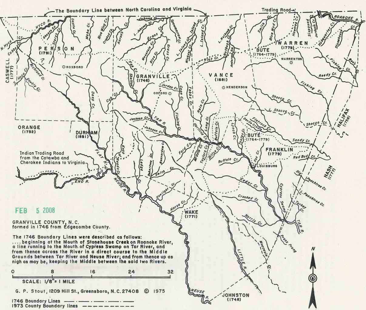
North Carolina The “Carolina” colony was named by King Charles II in 1663 to honor King Charles I (“Carolus” is the Latin form of “Charles” – 1629). All lands from the 31º to 36º north latitude to the Pacific Ocean (South Sea) were initially Chartered, March 20, 1662. The King amended this Charter on June 30, 1665 to enlarge the bounds from the 29º to 36º 30′ north latitude. The 30′ extension north eliminated an “ungoverned” zone about 35 miles wide (1º latitude is about 69 miles) referred to as “no man’s land” or “Rogue’s Harbor” at the time, and established a basis to eventually resolve the border dispute with the Virginia colony (Surveyor Col. William Byrd’s Line, 1728). It is interesting to note that Louisburg is at 36º 06′ north latitude – about 7 miles north of the original 36º north latitude – historically placing Lynch Creek and Rocky Ford well within “Rogue’s Harbor” of Lord Granville’s share. A land patent was granted to Heath in 1629 for what was originally called “Carolana” (see NC State Archives – British Records, Card Catalog #1). This patent was revoked by the King in 1632 to resolve any conflict with the new “Carolina” colony. The history of North Carolina consists of four periods: Colonization (pre-1663), Proprietary Government (1663-1729), Royal Government (1729-1789), and Republic (1789-present). The colony was divided into North and South Carolina in 1711 (along the 34º north latitude). The estimated population of North Carolina in 1730 was 30,000; by 1760, it was 131,000; and by 1790, it was 394,000. During the Proprietary period, Lord Granville’s ⅛ share of the Carolina colony was settled from the coastal plain westward towards the piedmont. King George II obviously favored the 1st Lord Granville, in person Sir George Carteret (1610-1680), by also granting him a ½ share of the New Jersey colony as well. Upon his death, John Carteret (great-grandson, 1690-1763) became 2nd Lord Granville who was the only Proprietor NOT to transfer ownership back to King Charles II in 1729 at the start of the Royal Government period. At the close of the Proprietary Period, there were no churches, schools, roads or mail service in the colony. Upon his death, Robert Carteret (son, 1721-1766) became 3rd Lord Granville. None of the Lord Granville’s ever visited the New World (America). Granville’s lands abutted Virginia encompassing what was then Edgecombe County. The inhabitants of Granville’s share were notorious for their “resistance” to paying taxes, and his agents (personal and later British troops) were likewise persistent in their attempts to collect “quitrents” as they were called. The term is derived because it “quit” the landholder from certain feudal obligations to which Lord Granville was entitled under provisions of the King’s Charter. Initially, quitrents were payable annually in pounds sterling; gradually, payment was accepted in provincial currency (first issued in 1715 – “Bills of Credit”); and finally, commodities-in-kind – concessions made to increase quitrent receipts. This “resistance” led to the formation of Regulators who “ruled” the area in lieu of Royal (British) governance originally headquartered in New Bern (colonial capital until 1774; Governor Tryon ruled 1729-1788) – thus continuing the “rogue” nature of the area. In 1777, the North Carolina assembly declared the new state as sovereign over all the lands between Virginia and South Carolina, though recognizing claims to land granted by the crown and proprietors prior to July 4, 1776. It also confiscated all lands and property of persons who supported the British during the war. Following the war the Carteret heirs were compensated in part for the loss of their lands. Franklin County The research of properties in now Franklin County is complicated by the fact that it was once originally part of Albemarle County (1663), then Chowan County (1670), then Bertie County (1722), then Edgecombe County (1732/1741), then Granville County (1746), then Bute County (1764), before it became Franklin County in 1779 – a portion of which subsequently became Vance County in 1881. Records are stored in different County repositories, as well as, the NC State Archives in Raleigh. Bute County was named for John Stuart, 3rd Earl of Bute, Prime Minister of Great Britain from 1762 to 1763. On April 26, 1777 Benjamin Seawell introduced a petition to the NC General Assembly on behalf of several prominent Bute County inhabitants for the division of the County – no action was taken at that time. Two years later, Edward Jones introduced another petition for division, and on January 20, 1779 – General Assembly convened in Halifax – a Bill was slated and enacted into law: “. . . That from and after the passing of this Act the County of Bute shall be divided into two distinct Counties by a direct line from Granville to Halifax or Nash County as the case may be, leaving each part or division and equal quantity of Acres as near as can be ascertained . . . and all that part or division which lies North of said line adjacent to Virginia shall be a distinct County by the name of Warren, and all that part or division that lies South of said line shall be a distinct County by the name of Franklin; …” (SRNC, XXIV, 227). Later in 1779 – October 18 to November 14 the General Assembly reconvened in Halifax – two other Acts of the Assembly established Louisburg and Warrenton as County seats. Each NC County had one elected Senator and two members of the House of Commons; borough towns (Louisburg) also elected one House member each. Green Hill and Thomas Sherod were the initial House members and Benjamin Seawell was Senator from Franklin County. Before Franklin County was formed and nearby Louisburg (the County seat) was established, it appears that many prominent families resided in the area north of the Tar (Tarr, Taw, Tau) River (more to follow). Louisburg (“the old fords of the Tar”) was named in commemoration of the capture by American forces of the French fortress at Louisburg, Nova Scotia. Louisburg was established in 1779 when Bute County was dissolved to form Franklin County (named after Benjamin Franklin of Philadelphia, PA) and Warren County (named after Joseph Warren who died in the Battle of Bunker Hill near Boston, MA), in a public action that reflected the common utterance “No Tories in Bute”. By contrast, Raleigh – the NC State capital named after Sir Walter Raleigh – was not established until 1792. Settlement of the Granville lands progressed slowly westward. Later settlement of the Piedmont and Mountain regions was southerly from Virginia and States north.
Lynch Creek Lynch Creek rises from a spring in southern Vance County (J.A. Gill property) flowing southerly about five miles until it empties into the Tar River north of Louisburg below Simms Bridge. Lynch (Linches, Lynches, Lynch’s) Creek was labeled on John Collet’s 1770 Map of North Carolina – which hints that it was named in earlier times (read on for details). Many conflicting stories exist about how the creek was named. Research is focusing upon deeded ownership of nearby Carpenter Lands (Joanne and Seth). Earl of Granville granted to James Linch in 1722; sold by James Linch to Frederick Cook in 1725 (from Wellman, “The County of Warren”, p10); Son Thomas Cook inherits the land; then Thomas sold property to Daniel Jones (stepson of Thomas Cook) in February 1767 with deed stating “property on both sides of Linch’s Creek”. I believe this “untangles” the many stories surrounding how present-day Lynch Creek was named (prior to Collet’s 1770 Map) Evidence is mounting that most early parcels granted by Lord Granville were for large tracts (640 acres to one square statute mile) whose locations were sensibly chosen to abut or straddle waterways to ensure accessibility. The waters of early North Carolina were the highways of today. No roadways existed, except the Indian Paths, and then as now, the topography of North Carolina makes westward overland travel difficult because of the many fords required to cross rivers and streams. It would seem that the naming of streams – as evidenced by Collet’s 1770 Map – reflected this initial ownership pattern – thereby strengthening my hypothesis that “Linch” Creek was named after James Linch in 1722. Many other waterway names reflect family surnames (e.g. nearby Tooles Creek and Eaves Creek), or names descriptive in nature, given by the owners – that persist to this day (e.g. Fishing Creek). Our study of Lynch Creek has recently been broken into four distinct stream segments:
The Tar River Land Conservancy (TRLC), which holds a Conservation Easement on our entire Lynch Creek Farm property, notes that Lynch Creek is a tributary of the “Middle Tar River Aquatic Site” that is recognized as ecologically significant by the North Carolina Heritage Program and administered by the NC Department of Environment & Natural Resources. Research Notes When researching early Franklin County, NC documents and deeds, don’t be misled by the fact that there are several Lynch Creek’s: in Albemarle County, VA; in Caswell County, NC; and in nearby South Carolina (many Civil War timeframe references).Early Land Surveying of a square statute mile (640 acres, English units) parcel of land was facilitated by the Gunter’s Chain used at the time that was 66′ long. A statute (vs. nautical) mile was 80 chains or 5280′. An acre was 1 chain wide by 10 chains long; thus a square mile was 6400 square chains / 10 square chains per acre = 640 acres per square mile.The nautical mile used for ocean navigation equals 6076′. Unlike the statute mile, a nautical mile is 1-minute (1′) of latitude. There are 60′ in 1º of latitude (about 69 statute miles).
Bridges NC State Archive documents from the Franklin County “Bridges” Folder revealed in December 1786 that “payment was ordered to Seth Mabry in the amount of £19.18s for the completion of a bridge across Lynches Creek for his settlement of County Taxes”. A similar document dated June 1790, “Ordered that Simon Jeffery, William Norozo(?), John Nicholson, Samuel Cannady and William Christmas be appointed commissioners to let the building of a bridge across Tarr River at or near Sims Ford to the lowest undertaker to be maintained seven years & that in addition to the instructions that may be made”. It also “Ordered that £50 shall be paid to the commissioners toward building the said bridge”. (Was this by George Sims – father of Joseph Sims?) Research Notes Locate Seth Mabry property – which bridge across Lynches Creek?
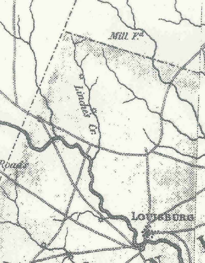
Was the Tar River bridge at Sims Ford by George Sims – see 1935 Smithwick Franklin Times article. Gill and Whitaker Mills Evidence of two separate mills along Lynch Creek – today commonly called the Gill and Whitaker Mills – has been noted on past maps (see 1869 Franklin County Fuller Map inset below) and foundation remains exist today. The 1833 McRae-Brazier North Carolina State Map shows (via its Legend) both the Gill and Whitaker Mill sites. Both Mills therefore pre-date 1833 and had dams across Lynch Creek.
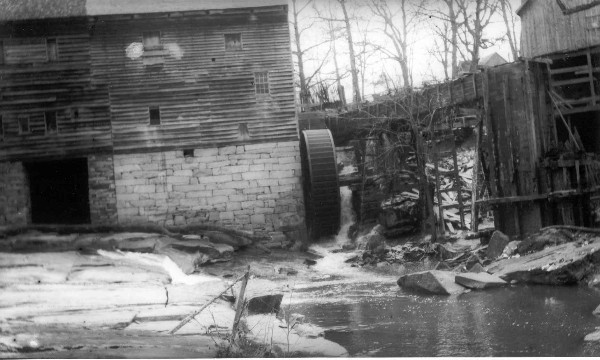
In a NC State Archive document (Shop Work Journal of Joseph W. Johnson for R.F. Gill – from the Will Folder of R.F. Gill) dated 12th July 1899, it appears that much unpaid repair work was performed on the Gill Mill from the period 13th November 1893 through 16th August 1897 prior to R.F. Gills death in 1898 (From the records of the Plank Chapel Cemetery, Vance County, North Carolina, 3046 Bobbitt Road, Kittrell, NC it is noted: Gill, Robert F, b. 1831, d. 1898, Plot #61). The probated will document itemizes many new mill “picks”, cold chisels, water wheel bands, rivets, threaded bolts etc. suggesting this may have also been a Saw Mill. (an aside – thanks to Doug Swords, the mystery of the term “frick” vs. “pick” in the hand-written manuscript was solved by a hand-writing expert). Payment to Johnson at times in the Journal was made in cash, or in bushels of Corn and Corn Meal. John A. Rogers recalls that Johnson (a black man) had a blacksmith/repair shop on now John Rogers Road opposite his present residence at 2543 Rocky Ford Road. The Whitaker Mill (noted on earlier maps as the Alford, and/or Goswick Mill) operated into the 1950’s. A review of Franklin County Aerial Photography dating back to 1936 (on file at the Franklin County Soil and Water Conservation office) failed to reveal a level of detail to establish the existence of supporting buildings in the vicinity of either Mill. A Franklin County Deed (DB 29, pg 608) dated August 15, 1848 from Joseph Sims to Jason Goswick conveys “a parcel lying on both sides of Lynches Creek . . . one hundred acres more or less . . . including my Mill and all the appurtenances thereto . . . for the sum of two thousand dollars” establishes that the Goswick Mill pre-dates 1848. Evidence is mounting that the Whitaker Mill may have been built in the 1770’s. A later Deed (DB 146, pg 413) dated February 16, 1889 from Joseph E. Alford to T.H. Whitaker conveys “one hundred acres more or less and known as the Alford Mill track” for the sum of three thousand five hundred dollars. Research Notes The NC General Assembly in 1715 delegated to the precinct courts authority to grant franchises in their respective jurisdiction for the construction of both wind and water mills. Two acres or more were to be set aside for the construction of a mill powered by water and one-half acre set aside for the use of a wind-type. Jason Goswick died in 1854 with a will to William H. Goswick. An Inventory of Property stated “One hundred acres of Land on which is a good mill” and other property valued at $1700 dated 20th September, 1871. Jason Goswick’s will was not probated by William who died intestate (without a will), so the fate of the Mill rested in the hands of heirs: Engrid(?) Power wife of Edward Power; Caroline Hight wife of Isaac Hight; Lucy Rudd, Emily Goswick, Mary Goswick, Robert Winn (infant), W. H. Goswick, Georgianna Goswick, Louisa Hister wife of W.H . Hister – all of Franklin County, NC – and Jason Goswick, Charles Goswick and Kurdred(?) Goswick infants of Warren County, NC. [Probate Court document dated 3rd September, 1871., NC State Archives]From the 1860 Slave Census Schedules in Franklin County, NC, we find that Robert Gill had 24 slaves, Eli Alford had 20 slaves , and Thomas (T.H.) Whitaker was not listed at all.Early in January 1837 the General Assembly of the State Of North Carolina at the Session of 1836-1837 issued a charter incorporating “The Town of Rolesville,” and named Eli Alford, John Lewis Terrell and Thomas Jefferson Terrell its first Town Commissioners. They were to serve until January 1838 when the first municipal election was to be held. The Commissioners had the power to tax the town’s inhabitants and to make ordinances and impose penalties for violations of the same. The penalties could not exceed $20 for each violation.From The Franklin Times, dated June 28, 1935 in an article by Dr. D.T. Smithwick, Historian for Franklin County, titled “Some Franklin County History”, subsection “Early Industries of Franklin County”, several interesting statements were made:
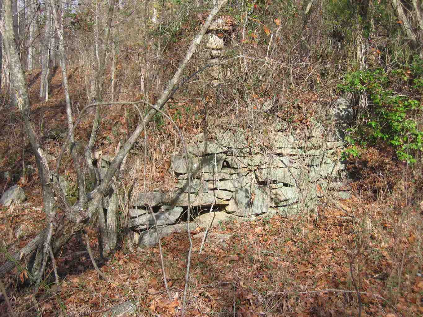
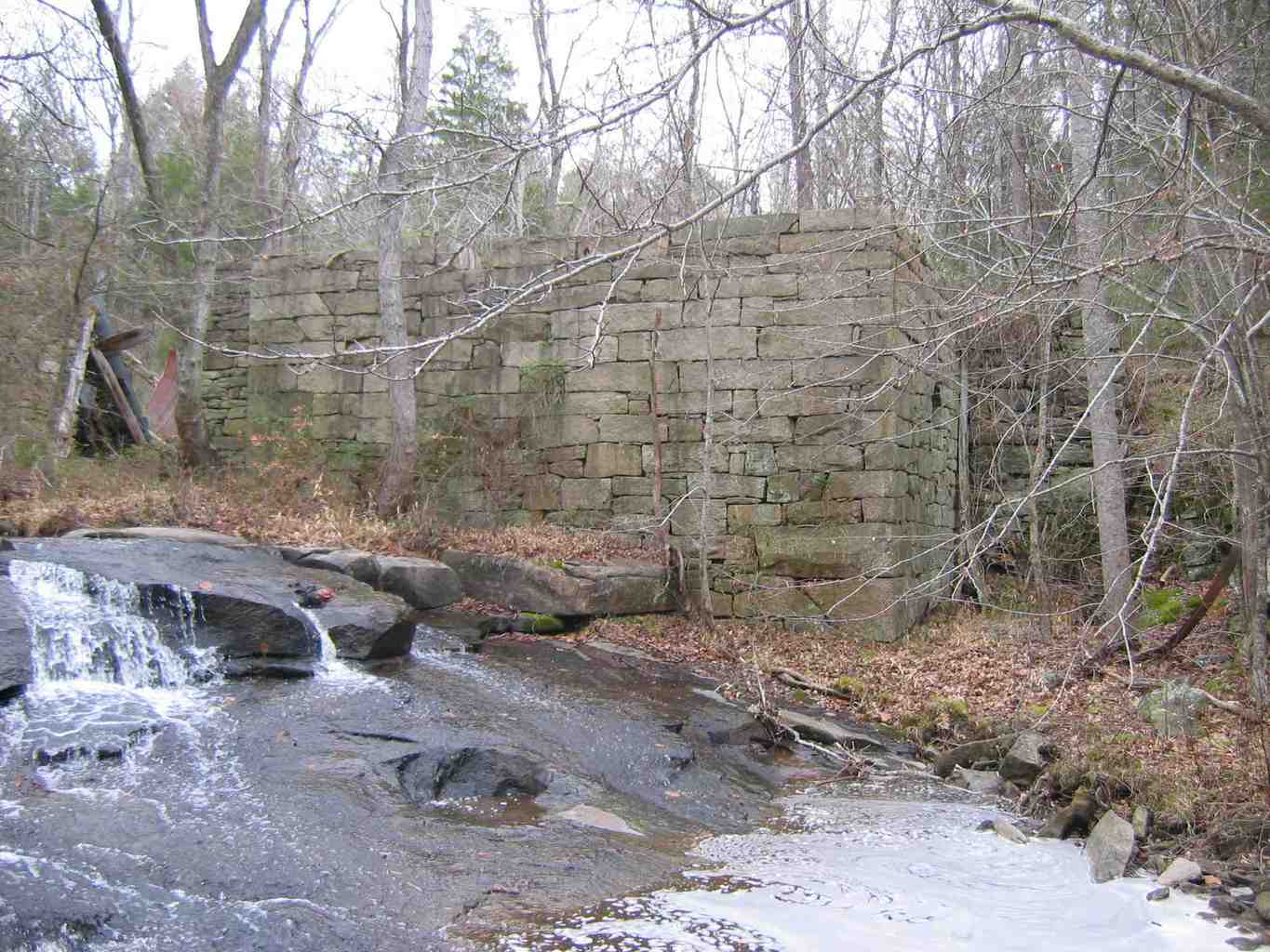
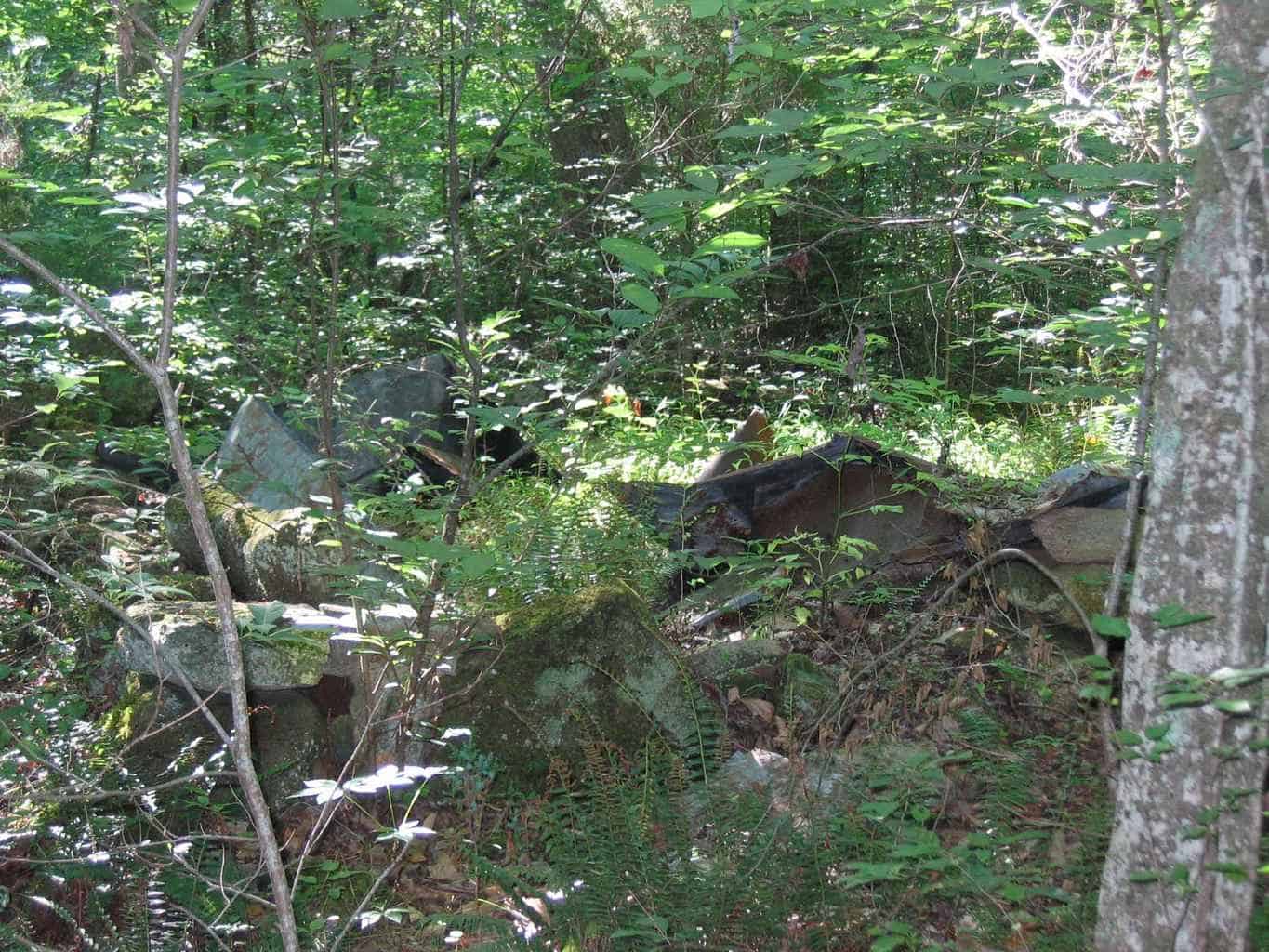
* Gideon Glenn – b.1715-1720, d. 1808, Franklin County, NC The first hand-drawn overlay version (1868, NC State Archives) of the 1869 Fuller Map (with Goswick’s Mill noted) exists and references an earlier Josiah Bridges 1840 (May 20th) Map that was mandated by NC State statute to establish School Districts – fifteen in all – indicating that the Sims/Goswick Mill existed prior to 1840. No copy of the 1840 Bridges Map itself has been located, but a written description of the school district boundaries has been located (Will Book “K”, Page 247). It appears that the first overlay version of the Fuller Map was hand-drawn to either reconcile the 1840 Bridges Map to the desired scale of the 1869 Fuller Map or to re-create Bridges Map from the written description. The January 2008 photographs below (taken by Bob Radcliffe) show the foundation remains of the Gill and now Whitaker Mills. Foundation of Gill Mill (Fuller Map, pre-1869) on Lynch Creek Foundation of Whitaker Mill (pre-1848) on Lynch Creek
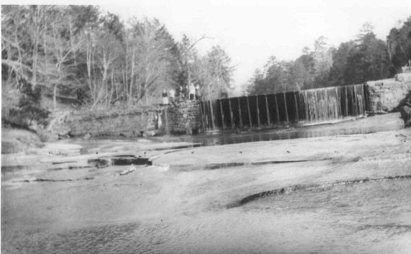
Photo (BELOW) – Whitaker Mill – main mill building, water wheel and tub-mill building Photo (BELOW) – Whitaker Mill Dam
The exact construction dates for both mills and the source of stone for the Whitaker Mill are being researched (see photos below). Nearby Cascine (Perry) Mill (30’x40′, three grinding stones) on Cedar Creek below Louisburg is of similar construction (foundation stone and cast metal gearing) and dates between 1825-1830. It seems likely that the Whitaker Mill (25’x30′, two grinding stones) replaced the older and less capable (or destroyed) Gill Mill.
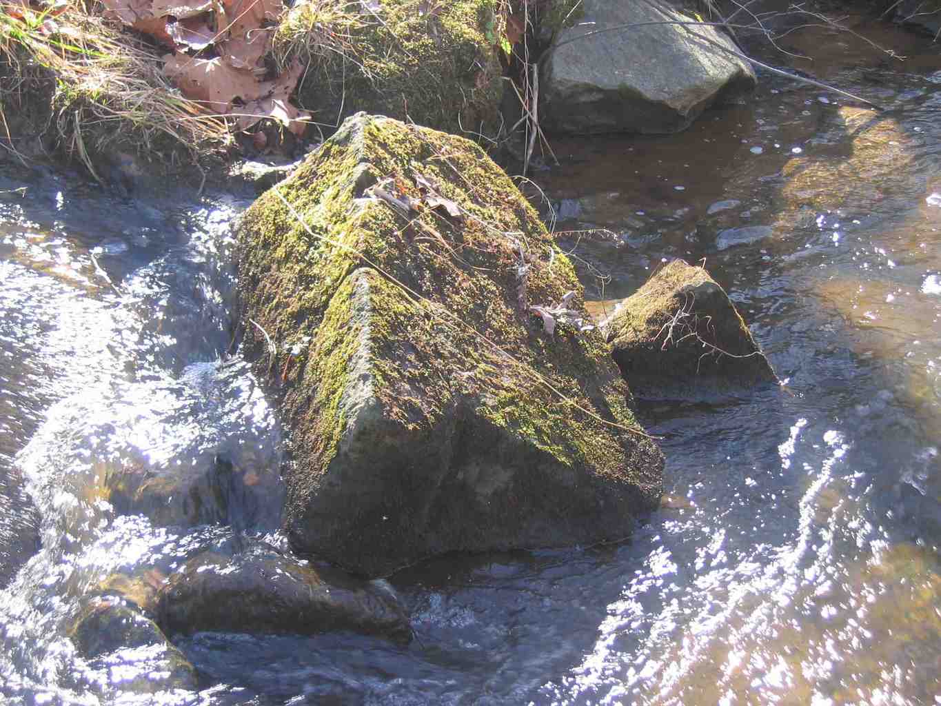
Possible Mill Quarry Site – Drill Hole in Rock and . . . . . . Rough Stone Block in nearby Tooles Creek Research Notes According to Susan Myers – NC Office of State Archaeology, Northeast Region, Staff Archaeologist and Site Registrar – neither the Gill nor Whitaker Mill have been registered and assigned permanent archaeological site numbers. Site locations are protected by state statute, and the more that is known for an area, the better it can be protected. There also does not appear to exist a Franklin County inventory of Mill Sites – such compilations are available for adjacent Counties (Granville, Nash, Vance, Wake, Warren).
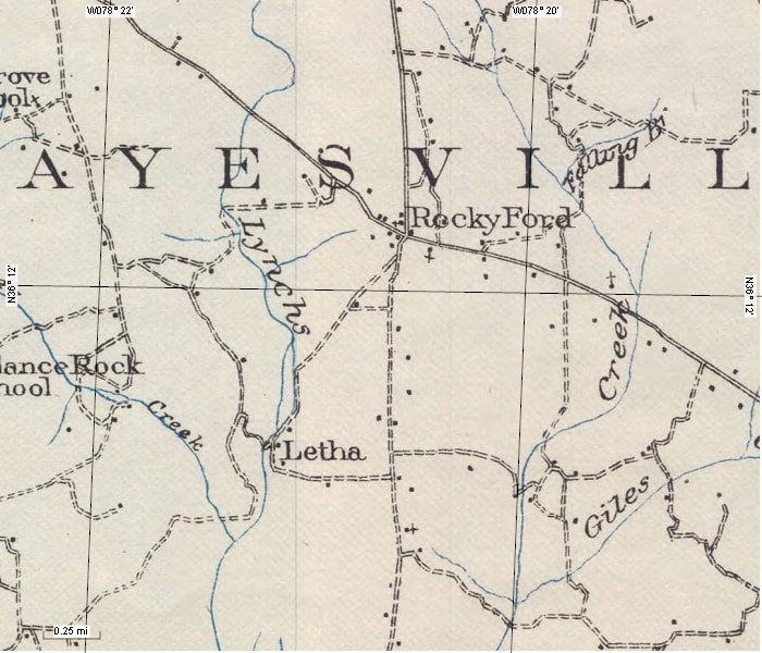
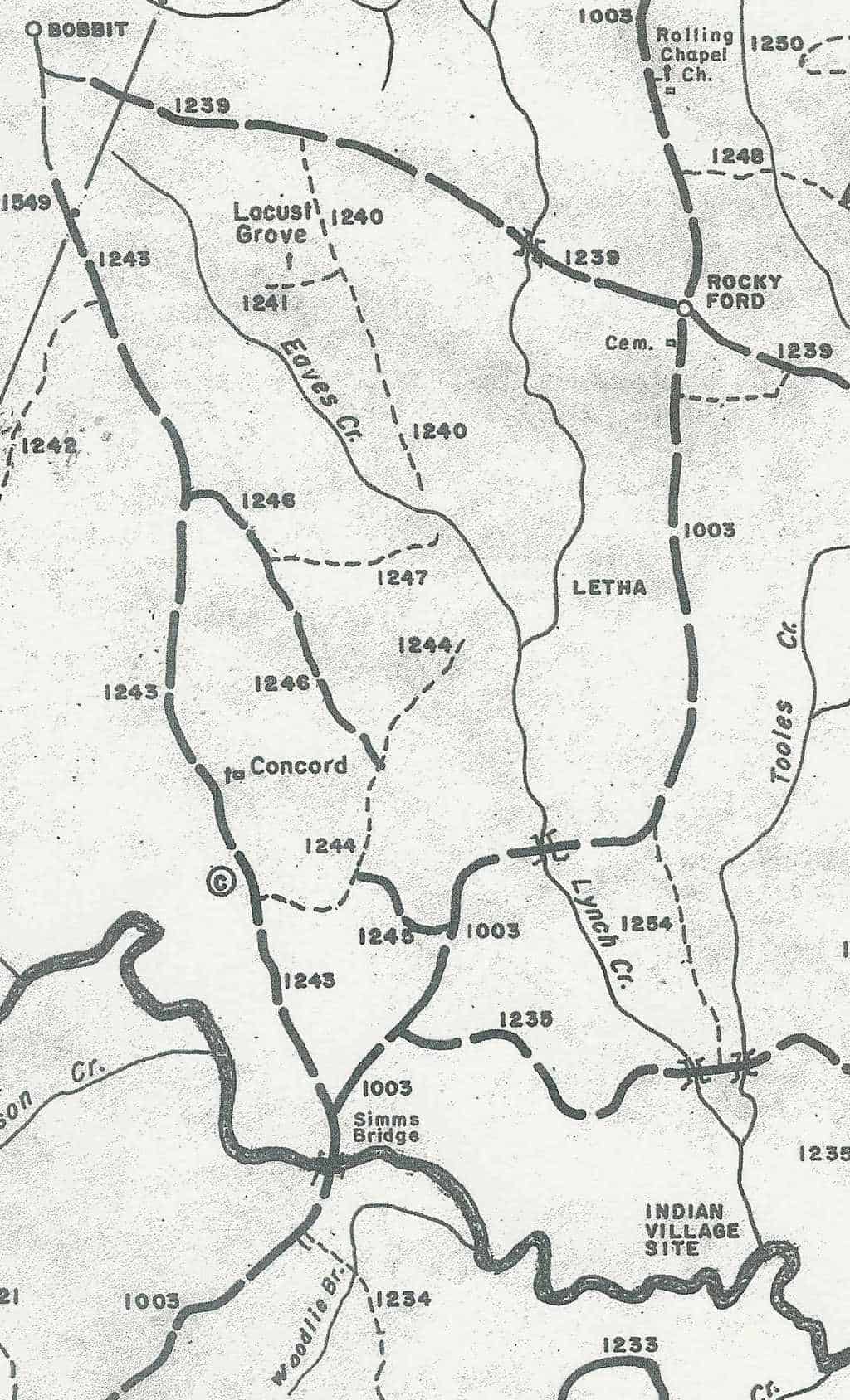
A nearby town named Letha (pronounced “lee-tha”, smaller than Rocky Ford) once flourished in the vicinity of Whitaker Mill, and was designated a US Postal Office from 1890-1910. (See the 1982 G.P. Stout Historical Research Map of Franklin County segment below). Mill operator, Thomas H. Whitaker (T.H.), is listed as a “Merchant not in Towns” from Letha in the 1907 North Carolina Year Book section on Franklin County. Left: Whitaker Miller House. Right: Foundation remains of Letha General store Letha consisted of a General Store, the Mill, a Miller’s House, supporting storage buildings, and a cemetery. The photos shown were taken in July 2008. Surprisingly, Letha vanished in the 1950’s, but Rocky Ford remains – if only as a namesake for the forgotten Haysville-Millford crossroad. The name Letha is a variant “Lethe” from Greek Mythology which is one of five Rivers in Hades that means “River of Oblivion”. A cup of water from “Lethe” makes you forget everything from your former life. Your soul may then cross the River Styx with help from Charon the Oarsman. Rocky Ford Although Lynch Creek Farm’s postal address is presently Kittrell (now in Vance County; past “Kittrell Springs” health resort), we are actually located in Rocky Ford (now Franklin County) on Lynch Creek. Rocky Ford is no longer the portage intersection that it once was for: 1) north-south transit to the Fords and Bridges across the Tar River at Sims Bridge and Louisburg; and 2) east-west transit north of the Tar River between Tarboro, Ingleside and Oxford – towns in the 18th century habited by prominent, wealthy, influential families (more to follow). Rocky Ford consisted of several buildings – a blacksmith shop, general store, schoolhouse, and cemetery – that are noted on early maps and serviced travelers passing through the area. Portion of 1915 Franklin County Postal Delivery Route Map Portion of 1906-1907 Franklin County Pratt Map
Rocky Ford was a US Postal Office in 1878 – prior to the introduction of Rural Free Delivery (RFD) which began as an experiment in 1896 and as an official service in 1902. It was customary for common gathering places (such as General Stores and Mills) to serve as Postal pick-up sites before the advent of RFD.
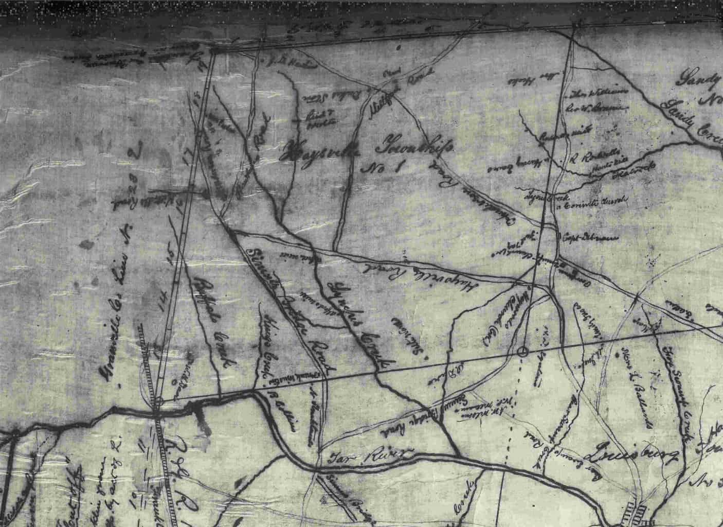
Portion of Land Surveyor, W. N. Fuller’s, May 1869, hand-drawn, Franklin County Map Present Rocky Ford Road was labeled as “Haysville Road” on W. N. Fuller’s, May 1869, hand-drawn map (second version). William Norwood Fuller ( b.1833, d.1912) was a noted Surveyor in Franklin County. The present northern crossroad, Epsom-Rocky Ford Road was noted as “Millford Road”, while the southern crossroad, Sims Bridge Road, was not shown to yet exist. Fuller’s map was drawn from a survey made by Josiah Bridges in 1840 – a copy of which has not been located. Fuller’s Civil War Reconstruction Era Map was commissioned to establish, for the first time, Townships which replaced the former irregularly-shaped Districts that evolved from the Proprietary Period of North Carolina history. Each Franklin County Township was labeled and numbered and bounded by equal latitude and longitude segments – the land area of which only vary along the perimeter with adjacent Counties. Note Fuller’s misspelling of “Haysville” (should be “Hayesville”) Road to coincide with the Township in which Rocky Ford resides – even to this day. Only the Freeman’s Township name has changed over time – renamed Youngsville Township. It was customary for roadways to be named for where they “took you”. Hayesville Road took you from Ingleside (eastern end of the now Rocky Ford Road) to Hayesville (presently named Bobbitt – the western end). Similarly, Millford Road “took you” to either the “Mill” (a Mill on Lynch Creek) or “ford” (a crossing point on Lynch Creek). Because the “present day” Sims Bridge (major ford of the Tar River north of Louisburg) Road was not shown on Fuller’s map, but the Millford Road was, suggest that the Gill Mill preceded the construction of the now Whitaker Mill. The Sims Bridge Road(s) noted on the Fuller Map segment above align with present day Bobbitt Road, and a re-aligned Beasley Road (which has also been labeled as Ingleside Road) that intersects present day NC 39/401. Similarly, Bear Swamp Road is now called the Dyking Road. The roadways at the Rocky Ford intersection were recently renamed: Hayesville Road became Rocky Ford Road, Millford Road became Epsom-Rocky Ford Road; but the Sims Bridge road remains, but was relocated. Over time, new roadway names were assigned to more appropriately describe where they “took you” – as the importance of the “mill” and the need to “ford” Lynch Creek and the Tar River at Sims Bridge, receded into history.
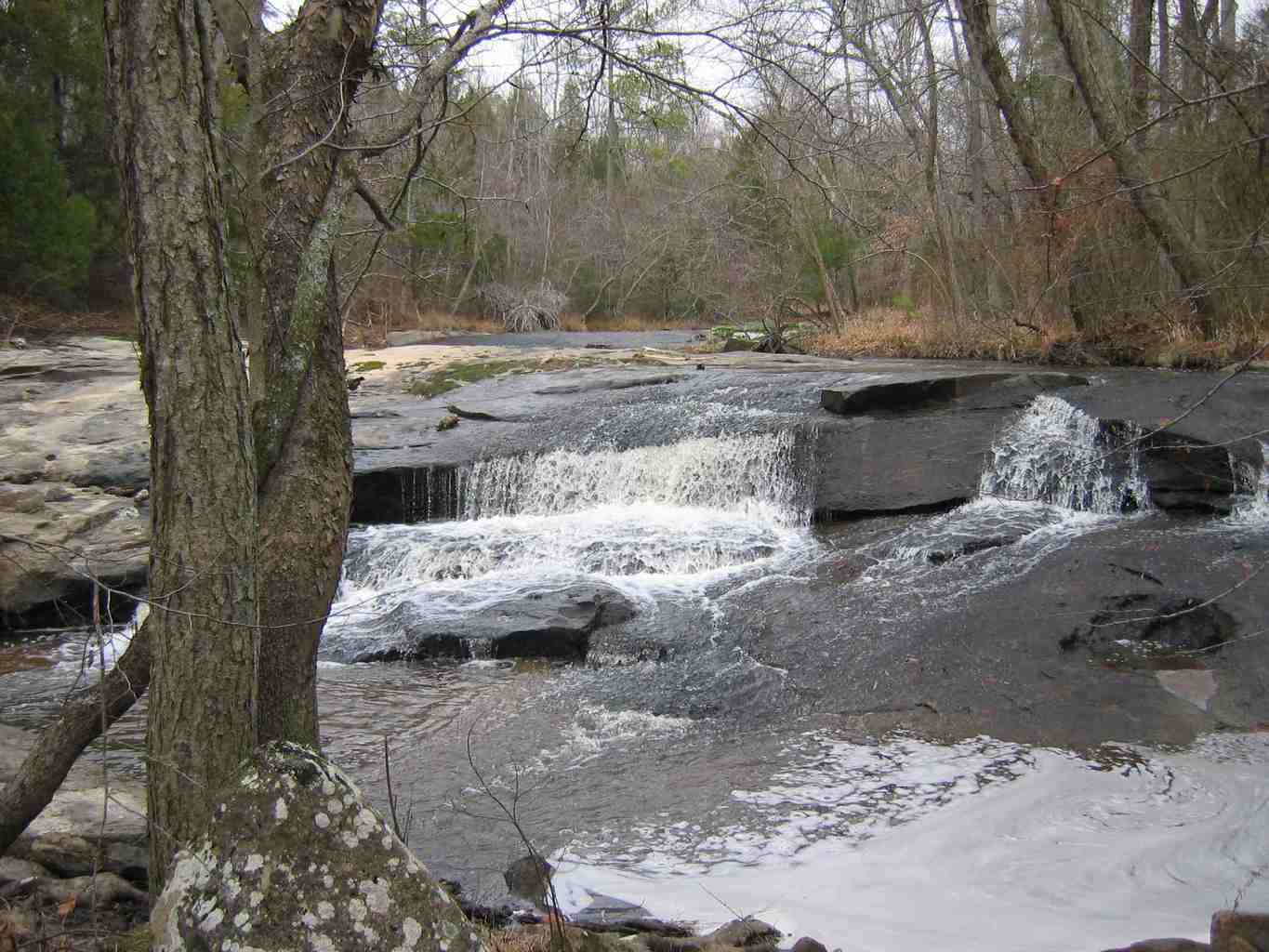
The “rocky” ford of Lynch Creek at Whitaker Mill, Letha, NC Research NotesThere as a Rosenwall School (dated 1926) in Rocky Ford – also Whitehall Chapel (per Mrs. Cheek) – per Joanne Carpenter, April 2013
Dyking Area The area along Lynch Creek between present day Sims Bridge and Dyking Roads (that parallel the Tar River) is referred to as the Dyking. The name is not a family name, nor a destination, but rather describes the “dykes” that were built along Lynch Creek in this area by early property owners (late 18th, early 19th century). Flooding along Lynch Creek – a tributary to the Tar River – in this area has always been a problem. Flooding was the demise of the Tuscarora Indians in the area (see below). The estimated 3000′ long drainage dyke (canal) is said to have been built to straighten and contain Lynch Creek and make the adjacent alluvial farmlands tillable. Such lowlands were prized for corn production – providing ample water and NO need to fertilize (natural flooding provides the nutrients). It is know that these lands produced corn under contract to support the Confederate Army. Dyke construction was a private, not a public, endeavor. This structure is unique and could very well be the largest such man-made structure in the County. Aerial photography (1955, G8-G9 Photos, Franklin County Soil Conservation Service files) reveals convincing evidence of this significant man-made structure. Individuals (Dement, Edwards, Faulkner, Pearce) recite stories and claim to have seen and walked along this structure in years past. It has been described to be built with a paved bottom (20′-30′ wide) and sides (4′-6′ high) made from large cut stone blocks like that of a mill foundation. Due to the presence of beavers and perhaps flooding over time, the area today is a marsh and impounds a large body of water. No visible evidence of the structure seems to exist. Further exploration is needed by watercraft to confirm the extent of this forgotten feature. Indian Trading Paths Before settlement by immigrants from coastal North Carolina and adjoining Virginia, the Lynch Creek area was inhabited by native American Indians – mostly Tuscarora – who habited the Piedmont between the Tar (Indian name “Tau” or “river of health”) and Neuse (named “Gow-ta-no” or “pine in water”) Rivers. The Tuscarora name for themselves “Skarure” signified “hemp gatherers”. “According to Douglas L. Rights’ book “The American Indian in North Carolina”, at the time of the first contact with Europeans, there were about 28,000 Indians, of which 5,000 were Tuscarora. Normal Indian population growth was significantly reduced, more by the impact of disease (brought by European contact), than from conflict. 1975 G.P. Stout Map of Edgecombe County (with Indian Trading Paths noted) The G.P. Stout “Edgecombe County” Map shows the main Trading Path (near present day Oxford), and other secondary paths near Lynch Creek towards Louisburg. Notice how these paths minimized the number of required fords to transit south-westerly. To gain a better understanding of North Carolina’s political climate and cultural aspects, President George Washington traveled by carriage and horseback throughout North Carolina on parts of the Trading Path in his 1791 “Southern Tour” (March-July, over 2000 miles, or about 20+ miles per day – the distance a horse could reliably travel). 1982 G.P. Stout Historical Research Map of Franklin County This location is near the “Indian Village Site” (on what today are the “Cannady Lands”) on the G.P. Stout “Historical Research Map of Franklin County, NC” last updated in 1982. According to one account, the knoll on which the battle was fought “was covered with skeletons, and as late as 1800, physicians procured bones from there for the teaching of anatomy”. Thanks to Skip Stoddard, NC Geologic Survey Geologist, who located the “mound” on former Cannady Land adjacent to the Tar River while surveying rock outcrops in the Louisburg Triangle Quad Sheet in May 2010. Franklin County GIS Topographic Maps clearly show the feature and Skip attests it is “not natural”. The location coincides with the location on Stout’s Map. A photograph of “Tuscarora Graves” near Louisburg is shown in the William S. Powell book “The WPA Guide to the Old North State”. It is believed that this photograph is mislabeled in the book. Efforts to resolve this by Radcliffe with the publisher (UNC Press) were futile. The migration (asylum of fugitives) of Tuscarora from North Carolina to the Iroquois Five Nations land in upper New York State that began in 1716 extended until 1766; however, many still peacefully remained. Others, like Henry Berry Lowry (The Lowry War, 1864-1874), became notorious, by violently resisting Confederate suppression in coastal Carolina (Pembroke).
Historic Structures
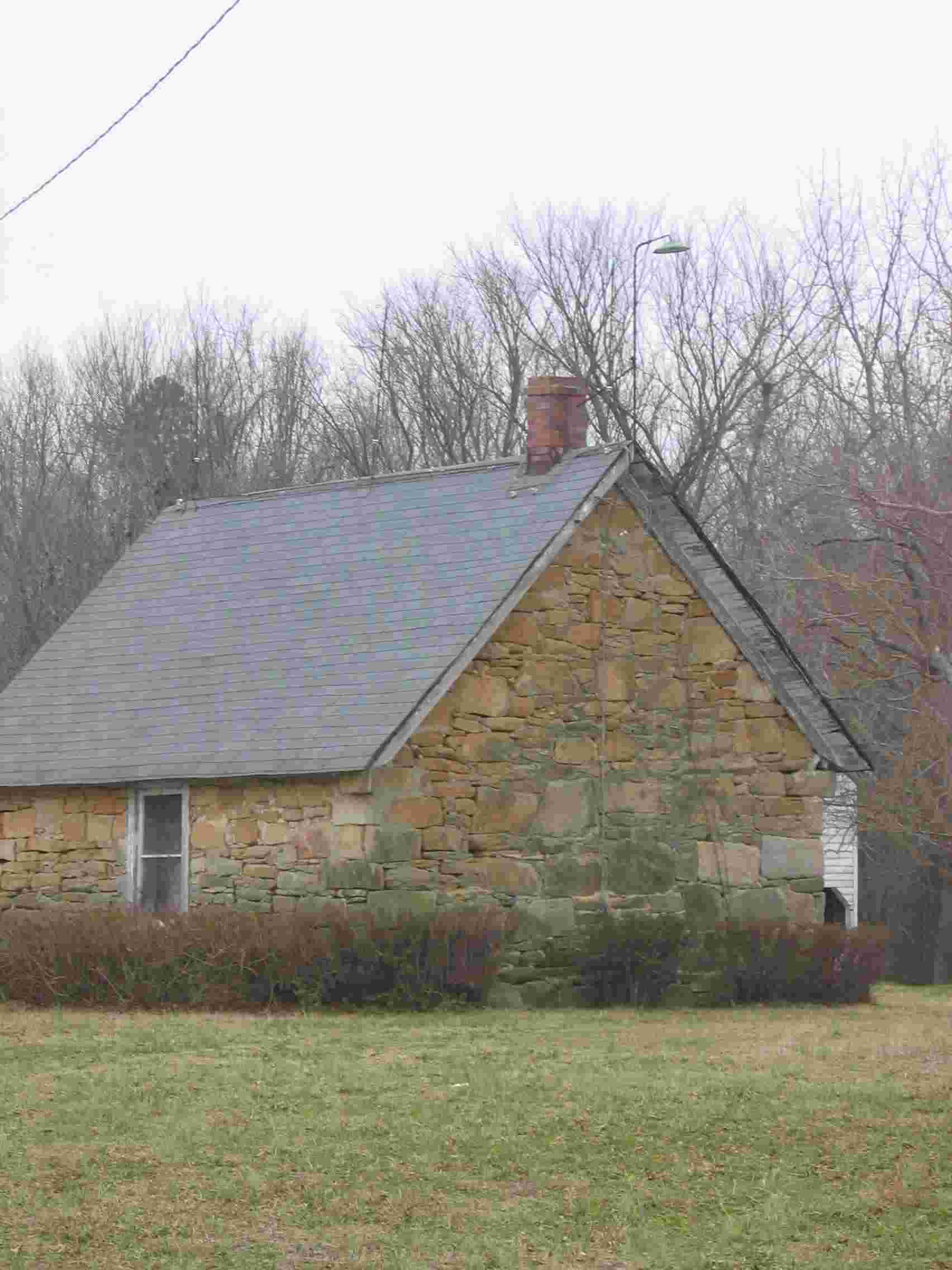
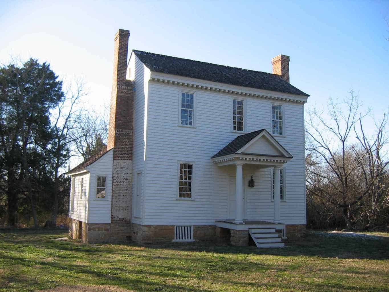
Another (circa 1780) National Register Historic Property is the Jones-Wright (Polly Wright) House in Rocky Ford that was noted in T.H. Pearce’s “Early Architecture in Franklin County”. Thanks to the extensive restoration work of owners Joanne and Seth Carpenter, what Pearce described in 1977 as “no possibility of this building being restored or even preserved”, has been beautifully restored and reinterpreted as evidenced by the recent photos below.
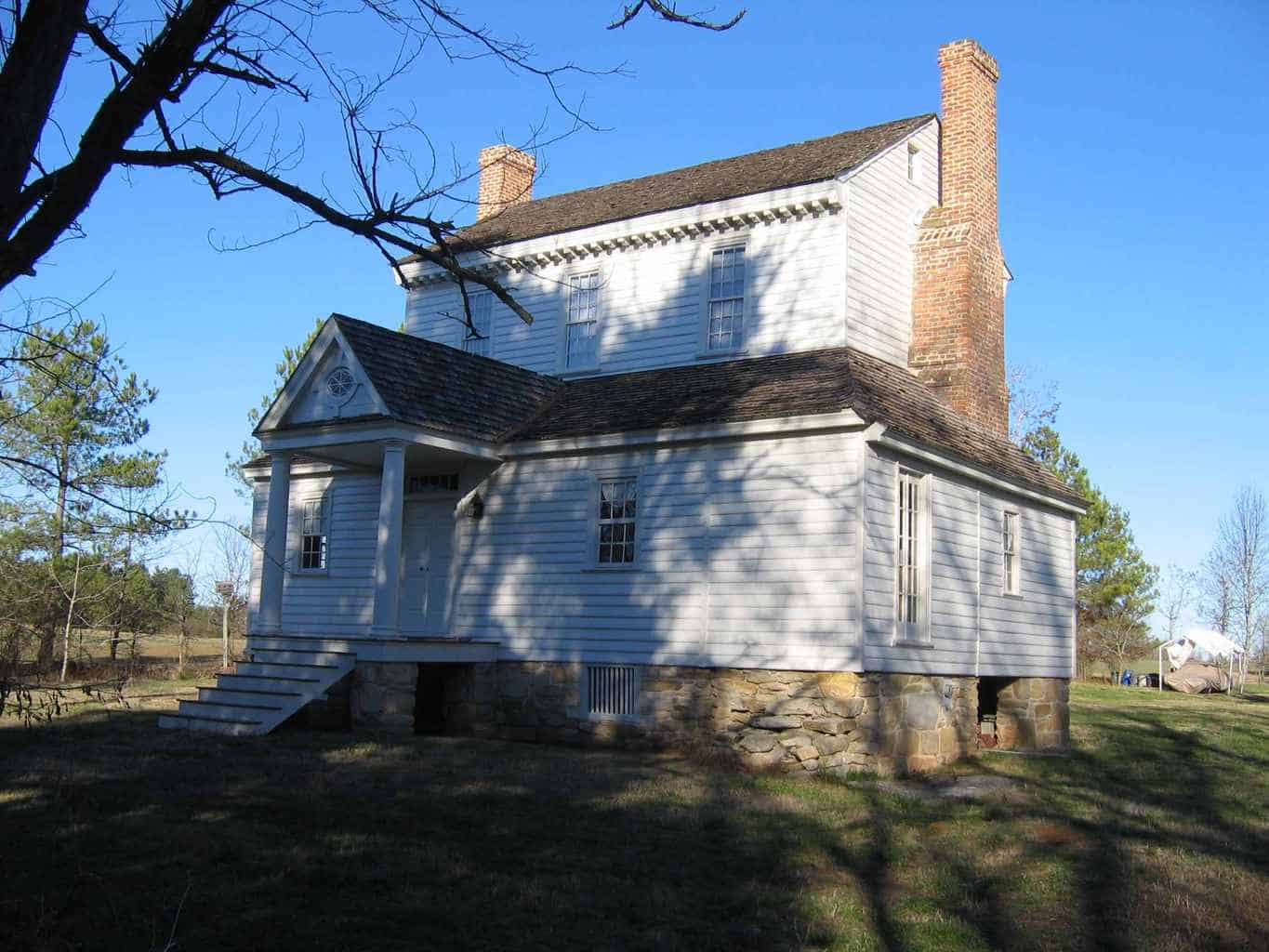
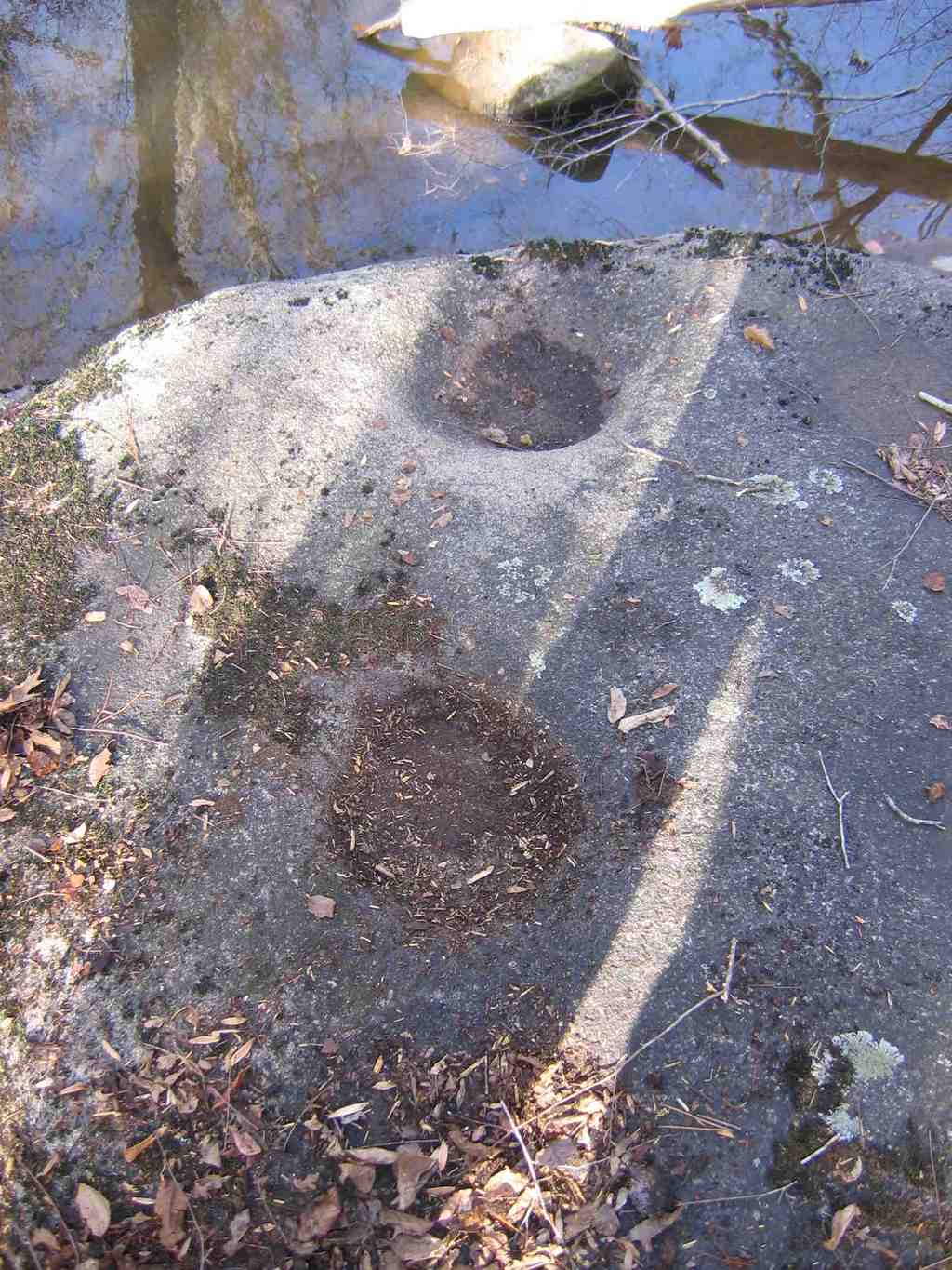
Front Elevation – Polly Wright House – Rocky Ford, NC – circa 1780 Rear Elevation – Polly Wright House The Carpenter Lands (about 200 acres – forest and pasture) abut Lynch Creek north of Rocky Ford Road. The Carpenters have entered in to a long-term lease agreement for Lynch Creek Farm to tend their open fields, transition the fields to organic hay production, and support the expansion of Lynch Creek Farm’s closed herd of Angus/Red-Devon, organic, grass-fed beef cattle. Ram pumps use no external power source, but rather rely on the compression of air from running water to generate the energy to move water uphill. The very spring that once supplied water for human consumption was “capped” in 2006 and fitted with an electric motor to irrigate Lynch Creek Farm’s apple orchard in 2007. It may someday again supply bottled drinking water. “Ram Pump” remains at Lynch Creek Farm Indian Grinding Marks on Boulders along Lynch Creek
The adjacent photograph shows Indian “bowl-shaped” marks in large boulders adjacent to Lynch Creek – probably used to grind corn – as suggested by the annotation of a nearby “Rock used by Indians for grinding corn” on John E. Buck’s 1931 Historical Map of Old Granville County. Indian corn was a predominant early settlement crop (before cotton and tobacco). Again, according to Susan Myers – NC Office of State Archaeology Site Registrar – this photographed site has not been registered and assigned a permanent archaeological site number.
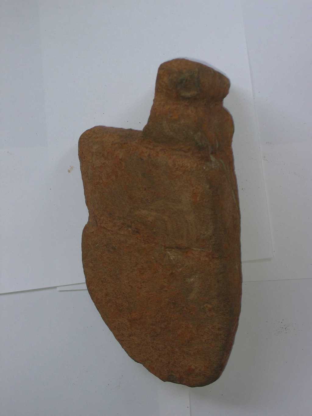
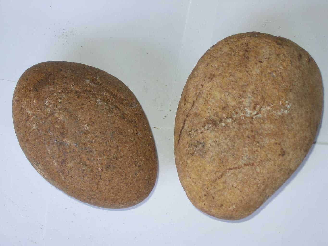
“Plow Tip?” and Grinding Stone Artifacts from Lynch Creek Farm Property – Bob Radcliffe Research to create a detailed description and photography of an early (c.a. 1600’s) timber “batteau” that was removed from the Tar River near the entrance of Lynch Creek in the late 1990’s (by C.L. Gobble, Tom Magnuson and others) and preserved by a university group in Wilmington, NC, remains to be completed. It is understood that the artifact is crated and presently being stored in a Louisburg, NC Public Works warehouse. (more to follow). Stories Lynch Law Research Notes See: The Franklin Times, dated March 6, 1903, under “College Notes (Lynch Law), by Matthew Davis.
See: “Lynch Law: An Investigation in to the History of Lynching in the United States” by James Cutler. For another take on the Mills at Lynch Creek, see the April 2008 Issue of Tom Magnuson’s Trading Path Newsletter. Credits Bob thanks Joseph Elmore for his direction, and Joanne Carpenter, Robert Edwards, Alvin Faulkner, Billy Lumpkin, Mary Murphy, Dr. Raymond Stone, John A. Rogers, William Spencer (and others) for their insight and encouragement along the way. Special thanks to Tom Magnuson for his Lynch Creek Mill Tour on April 3rd, 2008 and the complement of historians who trekked to the Gill and Whitaker Mill sites. American Indian in North Carolina, The, by Douglas L. Rights. Winston-Salem: John F. Blair, second edition. 1957
Contact Information Kindly forward any additions, corrections or suggestions to: Bob Radcliffe Tel: 252-767-1167 |